

King George’s Park, nearly was, The Down Estate & The Aqueduct
This series of blogs in our From The Archives series is intended as a resource for schools and local residents who are interested in researching local history.
School children should feel free to use the images in these blogs for their projects or homework.
We are very happy to help schools with access to relevant materials. However, the images that are reproduced here should be assumed to be the copyright and may not be reproduced without license from the archives and commercial use is therefore strictly prohibited.
Seeing John Augustus Beaumont’s success with The Wimbledon Park and West Hill Estates others were keen to get in on the money making action.
This lead to a proposal to create The Down Estate by the then owners of Down Lodge, which owned the lands, who were the Watney family.

The plan for the proposed Down Estate below, also survives in the London Metropolitan Archives.
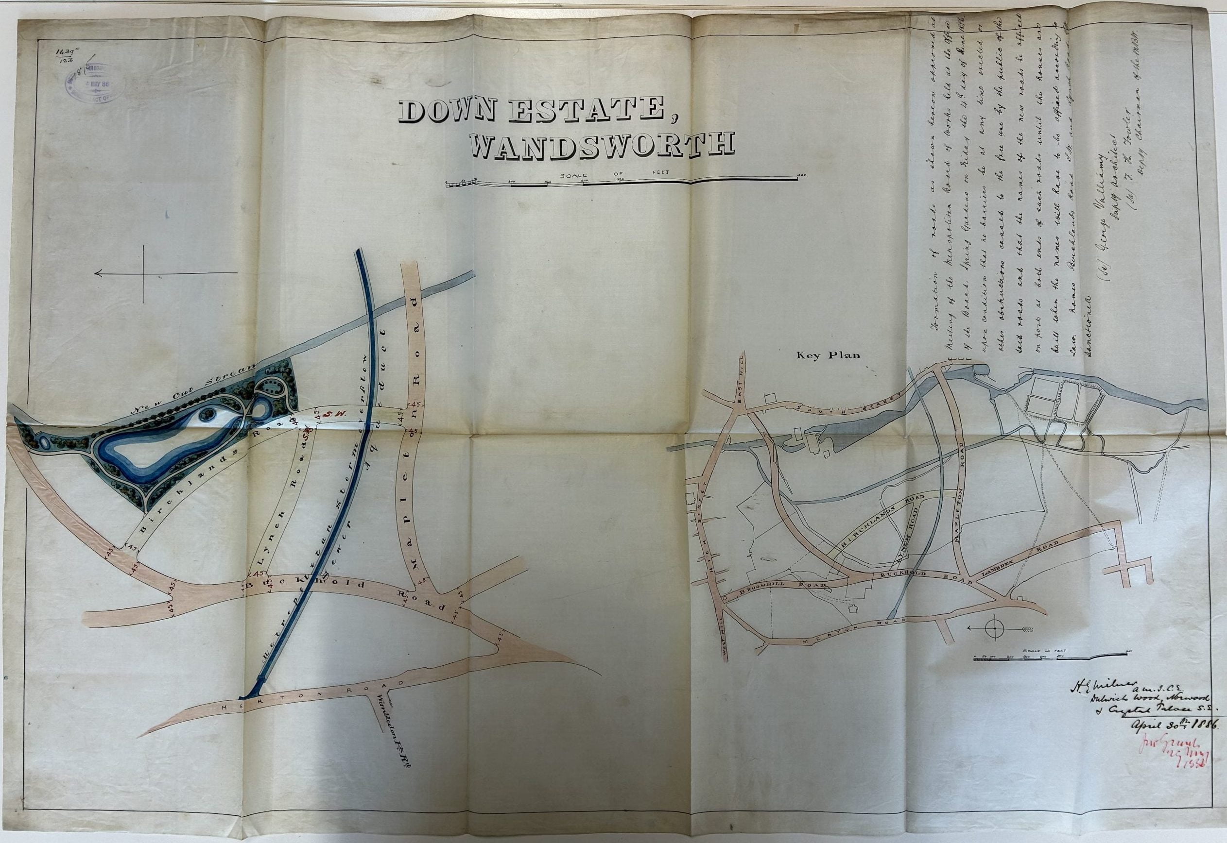
The Aqueduct – Designed by Sir Joseph Bazalgette
The aqueduct, marked on the The Down Estate 1886 plans, was created by Joseph Bazalgette extending his drainage scheme, the article states that this section of the scheme was finished around 1885. The original drawings, filed under The Southern High Level Sewer No 1 & dated 1882 [ACC/2558/LL/02/068B], exist in the London Metropolitan Archives but [unfortunately we cannot reproduce them due to rights issues] the drawings refer to Contract Number 614.

The tender was duly awarded to Mr John Waddell, a major contractor for MBW by the board 4th August 1882

Interestingly the owner of Down Lodge, Dr Watney, did ask for the design of the aqueduct to be varied to facilitate his Down Estate proposal which had been agreed on 30th April 1886. It would probably have been very hard for the board to have gone back on this earlier decision of theirs without having to compensate Dr Watney for the inconvenience to his plans.

This was then agreed a few days later on 8th December 1882 – if only we could be so flexible on major infrastructure project these days!

One aspect of major works such as this is compensating many of the properly owners disrupted by the works. This 1883 table shows the sums involved.
Explanation of the columns in the image below:-
- first column is the plot number on a plan that we cannot currently find
- second column is the property owner / tenants name
- third column is address
- fourth column is status leasehold / tenancy/ business – Do is a historical way of saying ditto
- fifth column is the amount claimed
- six column is the amount agreed – a very different sum
- seventh columns is how the agreed sum was arrived at

After the works were completed any lands above the line of the sewer appear to have been sold off. They must have been very confident that they wouldn’t have to dig it up again! Conveyance, below, means the legal process of transferring property from one owner to another.

he works appear to have been drawing to completion by 1885 as reported in The Building News Friday 23rd October 1885 Page 645. The most extraordinary thing is the mention that the top of the aqueduct would form a carriage way [road]. There is no evidence that there was ever a carriage way on top of the aqueduct and the photos of the time show nothing of the sort.

The article then goes onto make the following slightly bizarre claim. You can read the full article for yourself.

Below are some of the plans and drawings from a magazine called The Engineer.

In the plan below you can see how the aqueduct lines up with Ringford Road where is goes on towards Putney. This accords with the historical drawings that exist dated 1882 referred to previously.

The aqueduct required substantial repair works in 1919-22 and again in 1936 – looking at some of the files, drawings and photos, below, the tilt to the pillars become decidedly ridiculous.
There is a series of technical photos on the London Picture Archive spanning the 1930’s to 1951 which they have very kindly allowed us to reproduce under licence which clearly show the precarious state of the aqueduct and the continual movement and resulting deterioration of the structure.


The reason for the movement is explained in the following extract from a chapter entitled Sewers Across Valleys in Public Health Engineering Practice Volume ll: Sewerage and Sewage Disposal, L B Escritt, Macdonald and Evans, 1972 (l)SBN 7121 1641 9:-
When sewers are carried on aqueducts it is simple to arrange for the whole
of the cast-iron work to be protected against the weather, doing away with
the necessity for special arrangements for expansion. There is, however,
danger of expansion of the whole of the structure, which has on occasion
been overlooked.
Generally, this is not serious, and can be neglected provided
the aqueduct is straight throughout its length and abuts on solid ground at
each end.
If, however, an aqueduct were to be constructed with angles or on
a curve, there would be danger of movement towards the convex side, due to
expansion.
This happened in the case of the Wandsworth Aqueduct built
in 1882-5 to carry the Southern High-level Sewer. For some unknown
reason this immense structure consisting of brick arches supported on double
piers was constructed to an arc of a circle on plan, the sewers at the ends
entering tangentially and the convex side facing south.
The heat of the sun caused the aqueduct to expand longitudinally and, as
the ends abutted into the earth, the middle moved outwards towards the
south. Every summer the aqueduct moved farther south, returning only
part of the way back in the winter until the deflection became serious, break-
ing the northern legs of the piers.
Supporting buttresses were provided on the south side and of such
strength that when a high explosive bomb hit one during the Second World
War it only produced a scab of 2- or 3-feet diameter. Nevertheless the
movement went on and the aqueduct had to be demolished.
The aqueduct was demolished around 1968 [London Metropolitan Archive GLC/DG/PRB/35/002/361] and you can see where an additional pair of houses was built in the gap that the aqueducts piers occupied by Buckhold Road. You can see the very different style of construction of this later pair of houses.
Aerial photos
Prior to World War II AeroFilms undertook a large amount of aerial photography, in the preparation for war effort and most of their staff we subsumed into the RAF photographic recognisance branch for the duration of the war. This 1937 oblique aerial photograph is probably part of this series: documenting vital infrastructure.
This 1947 RAF vertical aerial photograph shows the post war state of the park and you can see a few bomb damaged buildings in the frame.
This oblique aerial photograph from 1961 shows the aqueduct and the park before the relief sewer was put underground, as it is today. You can see the old stadium in the background of the photo which is where the Southside Centre is today.
Ultimately King George’s Park was purchased from The Watney Estate in about c.1920 and turned into the public park it is now.
The images from The London Picture Archive are reproduced under licence.