
The Magdalen Estate: The Intersection of the Manors of All Farthing, Wandsworth and Battersea
This series of blogs in our From The Archives series is intended as a resource for schools and local residents who are interested in researching local history.
We are very happy to help schools with access to relevant materials. However, the images that are reproduced here should be assumed to be the copyright and may not be reproduced without license from the archives and commercial use is therefore strictly prohibited.
The Magdalen Estate and The Toast Rack are built on the lands of All Farthing Manor, bordering Wandsworth Common.
We have divided this part of the blog up into a number of sections by theme rather than by strict timeline.
The Manors of All Farthing, Wandsworth and Battersea: Wandsworth Common – this page
Sophia Sheppard’s ownership of All Farthing Lands – leading to Madgdalen College’s ownership
Wandsworth Common: from the manor to the people – why this stalled the development
The planning by l’Anson and building of The Toast Rack with Mr Kynock
The planning and building of The Magdalen Estate with Holloway Bros
Wandsworth Common from WWII to the present
Mediaeval Period
In mediaeval times Wandsworth Common was owned by the Church, but following the dissolution of the monasteries under Henry VIII saw ownership split between the separate manors of Battersea and Wandsworth.
It has been stated that the dividing line between Battersea and Wandsworth runs N-S across the Common. But it is really a rather more complex situation as it is the meeting point of the three manors of Battersea, Wandsworth & All Farthing.
All Farthing Manor
Few useful records for All Farthing Manor are extant. The earliest manorial records are held in the Westminster Abbey Muniment Room¹ and span the period 1365 – 1549 overlapping with records held in the Nation Archives spanning 1540 – 1622, Surrey History Centre and Northamptonshire Archives and Heritage Service hold other parcels of later material. The extant materials are extraordinarily uninformative.
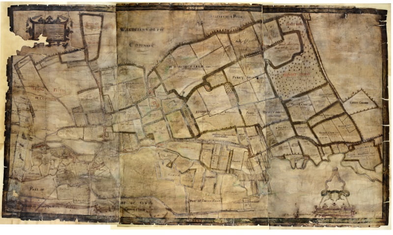
However, an interesting 1640 copy of a 1633 Map of the Manor of All Farthing has come to light in recent years.
Claims, therefore, that the John Roque map of 1746 – was the first to show an area called Wandsworth Common would appear to be ill founded: as we can see Wandsworth Common marked on this 1640 map, top centre, over 100 years earlier.
When the map is looked at, without getting too drawn into the fine detail the outline of the present day Magdalen Estate is pretty clear. All Farthing Piece, which became the Toast Rack, is shown slightly larger than the scale would appear to justify. It may well be significant that the lands of what becomes The Magdalen Estate are drawn with a thick border.
John Marshall’s Charity
The role of John Marshall’s Charity proved to be something of a rabbit hole. Yes, they did have a role in the manor but the titles of a number of documents proved to he highly misleading. It is is fine example of why not to get too excited about catalogue entries in old archives.
The one thing that this train of documentation does prove is just how fragmented All Farthing Manor was even by the mid 1600’s and certainly by the ended of the 1700’s the various manorial functions were so scattered that it would not have been administratively functional. This could well be why it proved impossible to effectively administer the manor in the late 1700 through to early 1800’s as its various income streams had been stripped away.³
John Marshall died in 1631 and it seems quite the coincidence that a substantial charity was set up in his will and a map produced two years later. Our initial working hypothesis is that the map was produced to aid the efficient administration of the land of the Manor probably by a number of parties. The full findings of our research into John Marshall’s Charity and All Farthing Manor are in the footnotes.
The Great Tithe
There is an map of the Great Tithe (below) – we can be thankful that it was extinguished otherwise a large chunk of Wandsworth would have been responsible for the repair of the chancel of All Saints, Wandsworth! The areas liable for the great tithe are, this time, actually coloured yellow.

There is little doubt that the Great Tithe was commuted (extinguished) in 1841.
In a document entitled “In the Matter of the Several Estates and Trusts arising under the Will of the later Mr John Marshall deceased” the Great Tithes were then commuted “The Great Tithes of All Saints Wandsworth in the County of Surrey – which on the 12th day of October 1841 were commuted for the sum of £525 [London Metropolitan Archives A/JM/006 p43].

This conflicts with the statement made in Edmund Brayley’s [History of Surrey, 1850, Volume III, pp 492-3] bear in mind the publication date of 1850 is well after the documented commutation of the great tithe.

We can trace the lands of All Farthing Manor thought the probate of George Porter Esq which is dated 3rd October 1683. Open the full PDF here.

This ties in with Edmund Brayley’s [History of Surrey, 1850, Volume III, Page 492] statement that, “Allfarthing manor had to be sold in 1652 but was recovered by Porter’s son and heir George (?1622-1683) and was retained by his descendants until 1811, when it was sold to Mr White.”
Mr Porter’s Papers, with conflicting dates, do show what was leased to whom and on what terms. On the outside of the fold they are marked as “Mr Porter’s Papers 1791 – A Particular of that part of the Estates of P. W. Porter Esq at Wandsworth as in now in Lease” and internally simply dated “July 1789.”
Some of the “Land Descriptions” use a name that correlates with the later tithe books and maps. However, the “No of Lease” doesn’t appear to correlate with any extant maps or plans. Still it is a useful document as it shows the yield from each parcel of land for that period. Assuming payments were made in full. Which by 1813 appears not to have always been the case. Open the full PDF here.

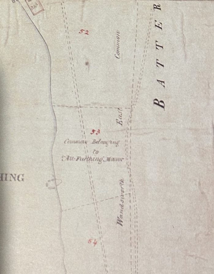
The first proper cartographic map of Wandsworth is John Corris’ Map of 1787, for Earl Spencer. Bear in mind that Earl Spencer did not control All Farthing Manor until the 1820’s but he did control all of the lands around it. This map shows the area of land that All Farthing Piece, which The Toast Rack stands on, as an empty field marked simply as 53.
However, we have to be careful with over interpreting Corris’ map as he was working for Earl Spencer for the specific purpose of documenting Spencer’s lands for estate management.
So it is possible that John Corris was not paid to detail anything more than boundaries on parcels of lands belonging to others. However, Corris does mark All Farthing Piece as ‘Common Belonging to All Farthing Manor’. John Corris’ notebooks of the time, which are extant in the Northampton County Archives [SOX 278(1) John Corris terriers], do not shed any light on the matter.
The footpath or track, on John Corris’ map, that passes across the common appears to describe approximate the route of what is now called Trinity Road. The total area of the common, based on the Tithe Maps, was about 400 acres.
Read on – The Earl Spencer Years
Victoria Histories Description of the Manor of All Farthing has a very different slant.
The manor afterwards known as ALLFARTHING appears in the second half of the 14th century as three separate fees in the possession of Westminster Abbey. (fn. 91) Lands in the first of these, in which in the course of time the other two became almost entirely merged, seem to have been held of the abbot by John and Gilbert of Allfarthing, tenants of his manor of Battersea, the former early in the reign of Henry III, (fn. 92) the latter about 1268. (fn. 93) Their name does not seem to occur again, but part of a Wandsworth estate which John de Molyns, lord of Stoke Pogis, (fn. 94) acquired in 1334 of John son of Robert de Domelton (fn. 95) was called Allfarthing, (fn. 96) and from 1366 onwards the manor of Allfarthing was accounted for among the possessions of the Abbot of Westminster. (fn. 97) The name of BARKING or BARKING FEE, the second holding, is found in the name of a tenant, John of Barking, who with his wife Alice and of her right held lands in Wandsworth in 1248 (fn. 98) and until 1253. (fn. 99)John was a tenant of the abbey in 1249, when the tithes of his land were assigned to the vicar of Wandsworth in the division then made, (fn. 100) and Alice was amongst the Wandsworth free tenants of the Battersea Manor in 1268. (fn. 101) She may have been succeeded by Peter of Barking, who served as a juror here about 1320. (fn. 102)
In 1368 and 1369 the abbot’s court was held in the fee of Barking, then apparently a separate manor, and from that time it remained one of the Westminster possessions. (fn. 103)
¹Personal correspondence with Dr Matthew Payne, Keeper of the Muniments, Westminster Abbey, 30th October 2023 “I am afraid that we have no maps or plans relating to Allfarthing at all ….. Although the manor known as ‘le Frithe’, and later Allfarthing, was purchase by the Abbey in the mid-fourteenth century, it has left relatively little trace among the archives. It was surrendered at the Dissolution in 1540 (having been leased by the Abbey to Thomas Cromwell in 1533), when Henry VIII annexed it to the honour of Hampton Court. So the only limited material we have relating to this estate dates from the late medieval period.”
²Ackworth also entered into an agreement with the Vicar dated 23rd November 1725 [London Metropolitan Archives P95/ALL1/026].
“Articles of agreement Between John Acworth, merchant, and Samuel Edgley, vicar, relating to rights in north aisle and next presentation to Vicarage.”
³The one thing that this train of documentation does prove is just how fragmented All Farthing Manor was even by the mid 1600’s and certainly by the ended of the 1700’s the various manorial functions were so scattered that it would not have been administratively functional. This could well be why it proved impossible to effectively administer the manor in the late 1700 through to early 1800’s as its various income streams had been stripped away.
John Marshall died in 1631 and it seems quite the coincidence that a substantial charity was set up in his will and a map produced two years later. Our initial working hypothesis is that the map was produced to aid the efficient administration of the land of the Manor probably by a number of parties. The date 1633 does lead directly to a deed [London Metropolitan Archives click A/JM/451 to open PDF] which is specifically concerning “of London Rectory, advowson and tithes of Wandsworth”. The deed is in medieval latin which does not aid its readability.


It is actually a complete red herring. The map is copied from John Corris’ map. This map is actually to do with the levying of the great tithe on Earl Spencer’s park lands as these are coloured reddish/purple.
Our conclusion drawn from Plan A [the freehold detail], of the Christopher Edmonds plan, is that John Marshall’s Charity never actually owned significant lands and that the small holding identified in the appended Plan A is the entirety of their freeholds in Wandsworth.

The deeds concerning the purchase of the great tithe & advowson are preserved in The John Marshall’s Charity archives [London Metropolitan Archives A/JM/468].
“Lease and release 1. Benjamin Sprint of London, gent. (brother and heir of late John Sprint), John Acworth, senior, of Wandsworth, dyer, John Acworth, junior, gent., Delitia Acworth, spinster, Gabriel Acworth, gent. (John, Delitia and Gabriel being the children of John A., senior, and all of Wandsworth) 2. John Neale, Alexander Kellett, Wm. Jackson, Richard Atkinson, Thomas Lowfield, Wm. Lowfield, Josiah Boyfield (Trustees of John Marshall’s Charity) Rectory and tithes of Wandsworth”
A rather more useful map sets out the considerable extent of the great tithe – we can be thankful that it was extinguished otherwise a large chunk of Wandsworth would have been responsible for the repair of the chancel of All Saints, Wandsworth! The areas liable for the great tithe are, this time, actually coloured yellow.